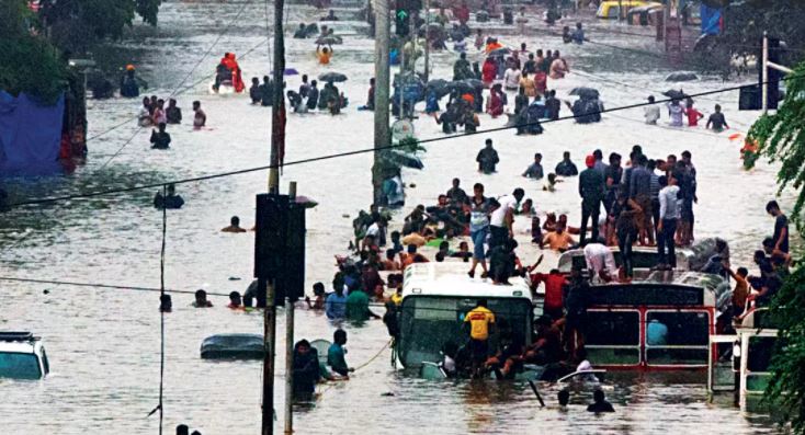
 On 26 July, 2005, around 2:00pm, as the people of the ‘happening city’ of Mumbai were going about their business, it was hit by a severe storm. It was the kind of storm that the city had never experienced in a century. It is normal for the city to receive around 240 mm of rain in a day but on that day the Indian Meteorological Department (IMD) station in Santacruz recorded 944.22 millimeters (mm). That was the day, the city which never sleeps, shut down for a full 30 hours. But that was a freak occurrence.
However, for the Mumbaikar, flooded roads are a never-ending annual cycle and a tale of neglect of the city’s internal infrastructure. All it needs is an hour of torrential downpour and the roads are inundated in knee-deep water. Why does this happen to the city every year? The Brihanmumbai Municipal Corporation, the country’s largest and richest civic body, promises not to repeat the previous year’s mistakes, but come the rains, the promises are submerged along with the floodwaters.
An interesting study* done by Prof. P. T. Kadave, A. D. Kale, and Shubham Narwade, from the Department of Civil Engineering, at K. K. Wagh Polytechnic, Nashik, titled “Mumbai Floods, Reasons and Solutions” reveals the scientific facts behind the reasons for the flooding in Mumbai every year. According to the authors,one of the main reasons is that since Mumbai is a low-lying area and shaped like a saucer, it is easy for heavy rains accompanied by high tides to inundate the city. But that is not the only reason.
Mumbai is the country’s business nerve Centre and, therefore, sees massive amounts of construction. To accommodate the construction and the industries, the waterways that allowed the accumulated rainwater to drain, have been drastically reduced. The reclamation that was carried out originally only to link the seven islands of Mumbai was eventually performed to a greater extent to accommodate the ever-burgeoning population of the city.
The ongoing construction has led to the proliferation of large slum colonies to house the labor that works on these sites, as well as planned constructions on the land reclaimed from the sea. Some of this development has also encroached upon the city’s existing storm water drains, to meet the housing demand.
The city’s existing storm water drainage system is a complicated system of simple drains and rivers, creeks, drains and ponds. The study quotes, “The network comprises of a hierarchical system of roadside surface drains (about 2,000km mainly in the suburbs), underground drains and laterals (about 440 km in the island city area), major and minor canals (200km and 87km respectively) and over 180 outfalls, which discharge all the surface runoff into the rivers and the Arabian Sea.”
Of these, some reach the Arabian Sea directly, while others empty into the Mahim creek, Mahul creek or the Thane creek. Additionally, some out-falls that drain out storm water from the western suburbs empty directly into the sea while the water from the remaining ones is discharged into the Mithi River which ultimately joins the Mahim creek.

The Mithi river serves as a dividing line between the city and the suburbs. Therefore, when it floods it has direct or indirect repercussions on traffic on the five transport corridors namely the Central Railways, Western Railways, Western Express Highway, Eastern Express Highway and the Harbour Railway Line.
To add to the city’s woes, the storm water drainage is encroached upon by a large number of hutments, storages, processing industries, workshops and scrap yards situated along its banks. These settlements make it difficult even to define the path of the river. Direct discharges of the untreated sewage, wastewater, trash from the unauthorised settlements and industrial effluents flow into the river’s course and choke it up, thus raising the level of water during heavy rains.
An interesting fact is that the storm water drainage system of the city was built largely during British Rule in 1860 when Mumbai’s population was one-tenth of what it is now. And it is not surprising that improving the drainage has never been a priority for any government or the civic body that has ruled the city. Ironically, when the drainage system was built it was capable of handling rain intensity of 25mm per hour at low tide. So, guess what happens when the rain intensity exceeds 25mm per hour and there is a high tide? This factor hit home to devastating effect when the city was hit by the storm in 2005. The city’s drains were just not capable of releasing the excess water quickly enough.
The reduction of the Mithi river catchment area because of extensive reclamation of land is not the only reason for the flooding. The Bandra – Worli Sea Link, a marvelous example of civil engineering over the sea to ease the traffic congestion in Mumbai and divert the heavy traffic going to the business district and returning from there in the evening, has had its downside too. The construction has constricted the mouth of the Mithi river at Mahim Bay. So, when the water from the river is discharged into the bay, during a high tide it surges back and overflows from the bank resulting in devastating floods.
Lastly, the runway for the Chhatrapati Shivaji International Airport has been extended over the path of the Mithi river which has virtually changed its course. Therefore, when it rains heavily, the water runs down with great pressure and instead of changing its path it climbs above the land surface and enters the city.
Also Read : Rings of Fire: athletes warn of heat risk during Tokyo Games
Also Read : Great Barrier Reef ‘in danger’ due to climate change and global warming
So, the next time you land or take off from Mumbai’s international airport, look down at the city you love from the window of the aircraft and ponder over what Mumbai might have been if the city’s planners, developers and politicians, had not allowed greed to override common sense.
 Jubilee Post News & Views


