Special Desk
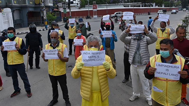
Nepal that shares border with India, has approved a controversial map where it shows Lipulekh, Kalapani and Limpiyadhura as parts of Nepal.Nepal’s Cabinet has endorsed a new political map showing Lipulekh, Kalapani and Limpiyadhura under its territory, amidst a border dispute with India. The new map includes 335-km land area including Limpiyadhura in the Nepalese territory.
Owing to the Nepal cabinet approval the Uttar Pradesh government has increased vigil along border. The Gorakhpur, Maharajganj, Bahraich, Balrampur, Lakhimpur, Pilibhit border areas have more vigil now.
The move announced by Foreign Minister Pradeep Kumar Gyawali came weeks after he said that efforts were on to resolve the border issue with India through diplomatic initiatives. Nepal’s ruling Nepal Communist Party lawmakers have also tabled a special resolution in Parliament demanding return of Nepal’s territory — in Kalapani, Limpiyadhura and Lipulekh.
Kalapani territory is an area under Indian administration as part of Pithoragarh district. The Lipulekh pass is a far western point near Kalapani, a disputed border area between Nepal and India. Both India and Nepal claim Kalapani as an integral part of their territory – India as part of Uttarakhand’s Pithoragarh district and Nepal as part of Dharchula district.
Gyawali said that the official map of Nepal will soon be made public by the Ministry of Land Management. Decision of the Council of Ministers to publish the map of Nepal in 7 provinces, 77 districts and 753 local level administrative divisions including Limpiyadhura, Lipulekh and Kalapani, he tweeted.
Gyawali last week summoned the Indian Ambassador Vinay Mohan Kwatra and handed over a diplomatic note to him to protest against the construction of a key road connecting the Lipulekh pass with Dharchula in Uttarakhand. India’s stand is that the recently-inaugurated road section in Pithoragarh district in Uttarakhand lies completely within its territory.
Minister for Culture, Tourism and Civil Aviation Yogesh Bhattarai said that the Cabinet’s decision will be written in golden letters.
Politicians in Nepal have a different view too. Senior Nepal Communist Party and member of Nepal Communist Party Standing Committee Ganesh Shah said the new move may escalate unnecessary tension between Nepal and India at a time when the country is fighting the.
The new map was drawn on the basis of the Sugauli Treaty of 1816 signed between Nepal and then the British India government and other relevant documents, which suggests Limpiyadhura, from where the Kali river originated, is Nepal’s border with India.
India and Nepal are at a row after the Indian side issued a new political map incorporating Kalapani and Lipulekh on its side of the border in October last year.